

El Niño has officially arrived: Here’s how it could wreak havoc on the weather
El Niño has formed in the Pacific Ocean and is expected to intensify in the coming months, meteorologists say.
The U.S. National Oceanic and Atmospheric Administration (or NOAA) on Thursday officially confirmed the arrival of El Niño, a prolonged period of warming sea surface temperatures in the central and eastern Pacific, which affects weather patterns across the globe.
For months, weather officials had been warning that a strong El Niño would almost certainly develop this year, driven by warm ocean waters near the equator.
What’s less certain is how strong this year’s El Niño will be. According to NOAA, there is a 63% chance between November 2026 and January 2027 of sea surface temperatures exceeding 2°C (or 3.6°F) above their historical averages — which forecasters would consider a very strong or “super” El Niño.
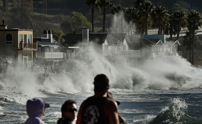
Such an event could saddle the southern half of the United States with a much cooler and wetter winter and ultimately fuel what could turn out to be the hottest year on record.
“El Niño conditions will pour fuel on the fire of a warming world,” United Nations Secretary-General António Guterres said.
Here’s what El Niño is — and how its rare “super” variant could wreak havoc.
Explaining El Niño
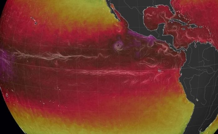
Normally, Pacific trade winds blow west across the equator, carrying warm South American water toward Asia. Cold water then “upwells” from the depths to replace the warmer surface water that’s been pushed away.
El Niño is a natural climate cycle that disrupts this pattern. It’s triggered by weaker-than-usual trade winds — winds that end up allowing much of that warm water to flow back toward the west coast of the Americas.
Ultimately, that warmer water forces the Pacific jet stream — a high-altitude air current that acts as a 7,000-mile “conveyor belt” pushing storms east across the Pacific toward North America — to move south of its usual path, altering weather patterns across the U.S. and the globe.
La Niña is the exact opposite: stronger trade winds, colder water and a Pacific jet stream that moves north rather than south.
El Niño and La Niña happen roughly every two to seven years and last nine to 12 months. El Niño generally arises more frequently than La Niña.
Weak, strong or ‘super?’
Meteorologists measure the strength of El Niño by how much the water temperature rises above average in a patch of the equatorial Pacific. The threshold for a weak El Niño is 0.5°C (0.9°F). The temperature is now just above that mark.
But to become a very strong or “super El Niño,” the equatorial Pacific would ultimately need to heat up by 2°C (or 3.6°F). That’s a lot less common.
If a “super El Niño” develops in 2026, it would be the first since 2015-2016 — one of the strongest on record, according to NOAA. Others occurred in 1997-1998, 1982-1983 and 1972-1973.
How would a ‘super El Niño’ affect the weather?
It’s hard to say exactly. The 2015-2016 “super El Niño,” for example, didn’t deliver a wetter-than-average winter in Southern California — one of its typical trademarks. At the same time, climate change has made what we know about previous El Niños less helpful for informing what could come next, because the ocean is already significantly warmer today than it was back then.
But some effects are relatively predictable.
In early May, NOAA said it’s “very likely” 2026 will be one of the five hottest years on record. That’s without accounting for El Niño’s warming impact. A “super El Niño” could make 2026 or 2027 the hottest year on record, displacing 2024.
Stronger El Niños also tend to flip the usual hurricane season equation, suppressing storms in the Caribbean and tropical Atlantic while amplifying them in the central and eastern Pacific. More tropical threats to Hawaii and the Southwest U.S. are a possibility.
Extremes of wetness and dryness — and heat and cold — are possible as well. Winter tends to get warmer in the northern half of North America and cooler and wetter in the southern half, especially in the Southeast and along the Gulf Coast. Elsewhere, drought could afflict the Caribbean, while India and Southeast Asia might see fewer summer monsoons.
The economic impact of these changes could be massive. According to a 2023 study published in the journal Science, the 1982-83 El Niño led to $4.1 trillion in global income losses, and its 1997-98 successor cut global income by $5.7 trillion.
Either way, “stronger El Niño events do not ensure strong impacts; they can only make certain impacts more likely,” Michelle L’Heureux, a physical scientist at NOAA, told USA Today. “There is still enough uncertainty that seeing a weaker outcome would not be a surprise.” (YahooNews)
The post El Niño has officially arrived: Here’s how it could wreak havoc on the weather appeared first on Newswire.